
Engineering-geological surveys describe the soil and rock a structure will stand on, and the groundwater around it. The results set the foundation type and depth and the design of earthworks.
What we do
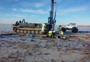
We drill boreholes, take samples, run field tests and prepare a geological model of the site, for land routes and for coastal and transition zones.
- Boreholes to the design depth, with sampling of each soil layer
- Field tests of soil strength and deformation
- Groundwater level measurement and seasonal observations
- Engineering-geological cross-sections and a site report
Methods and equipment
- Rotary and percussion drilling rigs
- Disturbed and undisturbed sampling
- Standard penetration test (SPT) and vane shear test
- Piezometers for groundwater monitoring
Deliverables
- Borehole logs
- Engineering-geological cross-sections
- Summary of laboratory results
- Technical report with foundation recommendations
Typical timeline
A small site with 5 to 10 boreholes is usually finished in 2 to 3 weeks, including laboratory testing. Linear routes take longer and are split into sections.
Request a quote
Send us the site location, the area and the deadline, and we will reply with a quote for your project.
Request a quote